
.gif)

Cottage Farm in 1842, 1876 and 2022
A Whiteparish local history page from younsmere-frustfield.org.uk
This page is currently being updated and not all new images have yet been uploaded.
**Working here** marked in text below
Previously filed as "Farm on Frenches Meadow", hence the filename.
A description of the history of Cottage Farm is conveniently described by starting with a recent description.
The Bramleys was built in the late 1980s on the site of the farm's orchard and at about the same time the farmhouse and farm buildings alongside were demolished and replaced with two houses that stand there today, 1 and 2 Cottage Farm.
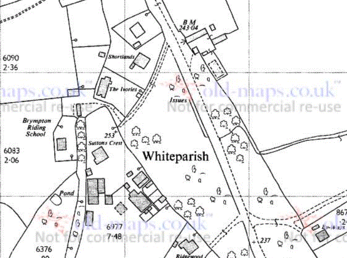
The three maps below give snapshots of the farm in 1842, 1876 and 2022. On the map on the left, Thomas Crook occupied the two areas shown in purple, 1246 a House and Garden at top left and 1231 Frenches Meadow and 1232 Sling on Frenches Meadow at bottom right. These were all were owned by the Countess Nelson (nee Frances Elizabeth Eyre). Two buildings are shown next to Common Road on the upper left corner of Frenches Meadow.
The second map, of 1876, shows the same farmhouse and outbuildings at upper left, while further farm buildings have been added to the two earlier ones on Frenches Meadow.
The third map shows the modern view of the area in 2022. The farmhouse and outbuildings at top left have been replaced by two modern houses, 1 and 2 Cottage Farm (a black spot highlights number 1). The farm buildings on Frenches Meadow have been reduced, but the group still includes buildings on the footprints of the two original 1842 ones. In the top left is a milking parlour in a very dilapidated state, with a Dutch barn and other outbuildings arranged around a concreted yard area. To bring the story up to date, earlier this month (June 2022) the milking parlour, Dutch barn and outbuildings along the road side of the plot were all demolished.
Cottage Farm in 1842, 1876 and 2022
Owners are listed for each plot of the 1842 Tithe Map. As seen below, the Countess Nelson owned Blaxwell Farm (one fifth of Blaxwell Manor) and also Frenches Meadow and Frenches Sling, while George Yalden Fort owned another of the fifths covering what is now Common Farm (renamed as Whiteparish Grange from about 1995). He also owned Long Meadow, and both were occupied by Amelia Percy.

Cottage Farm landowners in 1842
We know that when Leonard and Marjory Andrews' father married in 1915, he moved into the village from the family farm he had worked on at Redhill Farm. Marjorie recorded that "The farm was 50 acres, the average size of a farm in Whiteparish, which made a fair living though no one ever got rich. The rent was paid to the Nelson Estate. Father bought the farm in the early 1920's. It was basically a dairy farm, butter being made from the milk and sold locally. Hens and a pig were kept. Father farmed alone with hired local help at busy times. They ran a herd of 12 cows to start with, which gradually increased to 30."
This suggests that Cottage Farm was effectively one or other of these two one-fifth parts of Blaxwell Manor, although it is not easy to be absolutely sure which one. When The Bramleys was built, it extended over parts of Long Meadow, suggesting that Mr Andrews bought at least some of the land previously owned by George Yalden Fort. However, they farmed there until the early 1990s, by which time Common Farm was clearly established, and of course Blaxwell Farm also still covers much the same area as it did in 1842. How can we account for an area of 50 acres without either of these two farms?
This page covers two farmsteads.
1 and 2 Cottage Farm in Common Road were built on the site of the Cottage Farm farmhouse. This dated from 1915, when Leonard and Marjory's father married and moved into the village from the family farm he had worked on at Redhill Farm. The house and adjacent building were shown on the 1842 Tithe Map as 1246 House and Garden, although probably not a farmhouse at that time.
The second farmstead was situated opposite the entrance to Brympton Riding School. It was shown on the 1842 Tithe Map on 1231 Frenches Meadow, owned by the Countess Nelson (nee Frances Elizabeth Eyre) and farmed as arable by Thomas Crook. Frenches Meadow was used as arable at the time, with the adjacent woodland 1231 Sling in Frenches Meadow being pasture. Thomas Crook owned a house and garden (23) in The Street, and was one of the occupiers listed for 8 Cottages and Gardens (43) in Dean Lane near The Lynches, owned by the Countess Nelson.
In June 2022 the milking parlour that stood opposite the entrance to Brympton Riding School was demolished, along with the Dutch barn that stood to its right, a barn largely hidden from the road in summer by trees. Other small buildings on the site remain following the demolition. This small farmyard went through a succession of additions, removals and alterations through the years from before 1842 to as late as 1967. The milking parlour was in two parts, the older one nearest the road having been there in 1842. By 1876 a small farmyard had been added around it, but this had mostly vanished by 1900, when only the milking parlour remained. Two more buildings had been added by 1925 and by 1967 further buildings were added leaving the buildings much as they were up to the beginning of June 2022.

%20demolished%20milking%20parlour%20and%20Dutch%20barn.jpg)
The milking parlour in May 2018 and its remains along with the buildings left after its demolition on 9th June 2022
The new buildings shown on the 1967 map, including the Dutch barn demolished in June 2022, coincided with the first appearance of Cottage Farm on the same map, and were almost certainly associated with their dairy business. Cottage Farm rented its land from the Nelson Estate, this land being most of one of the fifths of Blaxwell Manor formed when Blaxwell was divided between 1622 and 1632. This one-fifth portion had been known as Blaxwell Farm and included the Blaxwell Farm buildings that still stand; the 50 acres of Cottage Farm represent most of the 62 acres forming Blaxwell Farm in 1842. My working assumption is that the farm buildings on the site were associated with Blaxwell Farm until 1967, although their exact function is unknown.
[See full transcript at foot of this page... Cottage Farm is referred to on pages 47-49 of Whiteparish 100 years. That has a picture of the Andrews' cottage, mentions that it was a dairy farm with 12 then 30 cows, making butter and selling it locally. Without tractors, milking by hand, heavy clay, common rights not exercised, sold Bramleys apples from their orchard by the bushel, this now being The Bramleys.]

Len and Marjory Andrews in the 1920s in front of Cottage Farm House
The rest of the Cottage Farm buildings stood where 1 and 2 Cottage Farm stand today, and appear to have consisted of a farmhouse with a possible farm building alongside, both of which were shown on the 1876 map. In 1842 1244 was a House and Orchard, 1245 was a cottage and garden, and 1246 was a house and garden and 1247 Two Cottages and Gardens. 1246 House and Garden appears to be the appropriate plot and show that the buildings were there already in 1842. [Add traced maps here showing the configuration at the various dates.] **Working here**
The farmhouse was replaced by two cottages and the orchard was developed in the late 1990s as The Bramleys, and since then the farmyard opposite Brymptons has remained derelict and the field in between used for depositing dung from the stables.
1967 1:2500 OS map (Old-maps.co.uk)
This page describes what were probably two separate farms at different dates, a "later than 1842 but earlier than 1901" farm that stood where the ruined milking parlour and Dutch Barn now stand opposite the entrance to Brympton Riding Stables, and Cottage Farm, first named on the 1967 map and still labelled as such in 1990. Two houses now (2022) stand on the site, 1 and 2 Cottage Farm. The Bramleys alongside was built on the Cottage Farm orchard. The buildings just south of The Bramleys were there certainly from before 1876 and possibly before 1842.
It seems likely from the maps that this is part of Cottage Farm referred to on pages 47-49 of Whiteparish 100 years. That has a picture of the Andrews' cottage, mentions that it was a dairy farm with 12 then 30 cows, making butter and selling it locally. Without tractors, milking by hand, heavy clay, common rights not exercised, sold Bramleys apples from their orchard by the bushel, this now being The Bramleys [see foot of page for full entry].
If this is the case then there was an earlier farm around the milking parlour that is now in a ruinous state opposite the Brympton Riding Stables entrance. From a couple of buildings in 1842 to a complex of farm buildings there in 1876 and then by 1901 a single building, the present milking parlour that was an advanced stage of decay was demolished along with other buildings on the site on 9th June 2022. A Dutch barn and few outbuildings were added by the 1967 map, of which only the Dutch barn remained standing in good order in 2021. Since the maps don't give the farm a name I've simply referred to it by the 1842 Tithe Map name of the field in which it stood: Frenches Meadow.
Planning application 15/01760/PNCOU (17th April 2015) for the "barn 30 metres east of Sunrise", this being the milking parlour, was prior notification of change of use from existing agricultural building to form a single dwelling and associated works.
At the north end of the area along Common Road, the buildings labelled in 1967 as Cottage Farm are there on all maps back to 1876 and even possibly on the 1842 Tithe Map [further research needed to assess the buildings west of Long Meadow along Common Road].
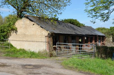
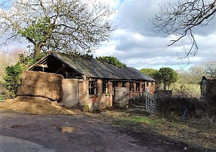
Photographs of the only remaining farm building, taken in May 2018 and January 2019. This building dates from before 1842.

The stalls within the section of the building closest to the road (all painted white inside - this is a colour picture).

The roof structure inside the building.

A vertical photo showing roof and stalls as above.

20190303_130837 Doorway March 2019.jpg

20190303_130848 outside of milking parlour March 2019.jpg

20190303_130947_0 outside of milking parlour close up March 2019.jpg
.jpg)
Frenches Meadow farm buildings map pre-9-6-2022 (W Planning).jpg
Signs of demolition activity started with the erection of builders' fencing around the weekend of Queen Elizabeth's Platinum Jubilee celebrations in June 2022. On Thursday 9th June 2022 a digger was pulling down the walls of the dairy as we passed in the middle of the morning, and only the roadside half of the building was still standing. When we returned late in the afternoon the site was clear except for piles of rubble as photographed below on the next day, 10th June 2022.

109-DSC_0576 2 Demolished milking parlour 1.jpg
The building was in two sections, possibly with 4 stalls in the nearer one and ten in the further.
 demolished milking parlour 2.jpg)
DSC_0577 (2) demolished milking parlour 2.jpg
 demolished Dutch barn 1.jpg)
DSC_0578 (2) demolished Dutch barn 1.jpg
 demolished milking parlour and Dutch barn.jpg)
DSC_0580 (2) demolished milking parlour and Dutch barn.jpg

DSC_0581 milking parlour demolition 1.jpg

DSC_0582 milking parlour demolition 2.jpg

DSC_0583 milking parlour demolition 3.jpg
 demolished Dutch barn 2.jpg)
DSC_0584 (2) demolished Dutch barn 2.jpg
The Google Earth pictures below were collected on 10th June 2022 to ensure these were archived before their inevitable replacement in due course.
.jpg)
Frenches Meadow farm buildings aerial view pre-9-6-2022 3 (Google).jpg
.jpg)
Frenches Meadow farm buildings pre-9-6-2022 (Google).jpg
.jpg)
Frenches Meadow farm buildings pre-9-6-2022 2 (Google).jpg
.jpg)
Frenches Meadow farm buildings pre-9-6-2022 3 (Google).jpg
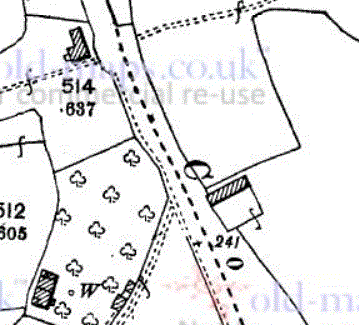
On the 1842 Tithe Map there are two buildings on the edge of Frenches Meadow opposite the point where Doves Lane leaves Common Road to pass the Brympton Riding School. By 1876 a complex of farm buildings stood on this site (371 on the 1876 1:2500 OS map). This was short lived as by the time of the 1901 OS map just the present building remained, this being one of the original pre-1842 buildings. More buildings were added by the late 1960s [research further]. As can be seen from the photographs above, this isn't expected to last much longer.
[I have a series of further photographs of this building dating back some years.]
 . .
. . . .
. .
1842 Tithe Map, 1876 1:2500 OS map (from old-maps.co.uk) and 1901 OS map (also old-maps.co.uk)


Cottage Farm in 1876 and 1901 (OS 1:2500 from old-maps.co.uk)


Cottage Farm in 1925 and 1967 (OS 1:2500 from old-maps.co.uk)

Cottage Farm 1990 (OS 1:10000 from old-maps.co.uk)
Exploring the possible extent of Cottage Farm, the tracing below roughly follows the boundaries of a block of Countess Nelson property on the 1842 Tithe Map. This area is 62 acres, whereas Whiteparish 100 years states the farm was 50 acres. It also included The Bramleys, so is implied to include the strip of land along Common Road owned by George Yalden Fort in 1842.
One possibility is to add the George Yalden Fort area (Long Meadow, 1242, almost 6 acres), then remove an area of 18 acres for Blaxwell Farm, with the maps below showing an area of 18 acres removed around Blaxwell. The remaining area, plus Long Meadow, would then be about 50 acres.


Cottage Farm was 50 acres, this boundary of Nelson property is 62
On the Tithe Map in 1842, Elizabeth Stone rented Blaxwell Farm from the Countess Nelson, including all the land that would later be Cottage Farm.


1842 Tithe map owners
Planning permission was granted to demolish 2 Cottage Farm and build two properties in its place, reported in the Salisbury Journal online on 12.2.2022. There was an earlier planning approval in 2000 for a similar plan.


1 and 2 Cottage Farm at the beginning of 2022 before number 2 (right) was demolished to replace with two properties (photo (c) 2022 Google)
From 'Whiteparish 100 years of an English Village'
Mr and Miss Andrew's father lived in and worked a family farm, Redhill Farm, on the other side of the A36. When he married he moved into the village in 1915. The farm was 50 acres, the average size of a farm in Whiteparish, which made a fair living though no one ever got rich. The rent was paid to the Nelson Estate. Father bought the farm in the early 1920's. It was basically a dairy farm, butter being made from the milk and sold locally. Hens and a pig were kept. Father farmed alone with hired local help at busy times. They ran a herd of 12 cows to start with, which gradually increased to 30.

Len and Marjory Andrews in the 1920s in front of their farm home
They were relieved when the Milk Marketing Board was founded in 1933 and a fair price could be obtained for milk. Before that farmers had to find their own contracts to sell milk or butter. The farm was run without tractors, the family was not mechanically minded, and also tractors did not seem to be reliable enough. The land was heavy clay, which was difficulat to manage, "not boys land" it used to be said.
Both Mr and Miss Andrews went to school in the village. Mr Andrews stayed on the farm to help father, farming through the depression of 1929 when value of stock etc. was halved.
Brother Leonard (Mr Andrews) retired entirely from the farm in 1989. The milking was done by machine. The cows could not run on the clay fields in winter. The farm started with Shorthorn cattle but changed to Freisians in the 1940's for milk better suited for butter. Father and son managed the farm, with mother in the background. Miss Andrews went away to work but came back to help out on the farm when her mother died as the farm could not afford a hired hand. They sold Bramley apples by the bushel from their orchard, which is now "The Bramleys". The farm was fertilised with natural products, no artificial fertilisers. The farm had a telephone fairly early otherwise it meant riding on a bike into the village to make phone calls.
Mr Andrews and Miss Andrews did not take advantage of their 'common rights' in Whiteparish for fear of their animals being a nuisance to others. They can remember forest ponies wandering in the village area. There was a pond in the village in Common Road near Pondside cottage. [This is presumably Poundside Cottage - an error perhaps?]
Miss Andrews, as a child, recalled that poor pensioners drew their 10/- a week pension but with 2/- for rent, a bit for coal, they had nothing left for clothes. They seemed to wear the same clothes summer and winter. She can recall various cottages dotted around the village, many thatched, which were wonderfully warm in winter and cool in summer but a terrible fire risk.
Miss Andrews recalls the poverty in the village. Children with very poor shoies and always looking half-starved but it made people tough. There was not a lot of casual work and any work had to be competed for.
Marjorie Andrews was born at Cottage Farm, Whiteparish on 18 October 1915. She lived there all her working life, running the dairy farm with her brother.
Her home later was in Common Road, until 8 years ago when she moved to Milford House Nursing Home.
She was great friends with Shirley Near’s late mother, and Shirley is one of the LPA’s who regularly visits her.
Marjorie keeps in touch with many folk who belong to the Friendship club and she enjoys the Steeple and Street which Jane Legat sends her every month. She has family who still live locally and keep her up to date.
Marjorie is looking forward to seeing inside the new Memorial Hall. When I visited her, she told me all about a hall they used to use which was the middle cottage of what is now The Lynches in Dean Lane!
Hugh Burnard is very kindly going to transport her to and from the fete and she is very excited about her role. As the theme of this fete is “100 years ago”,I think we are very fortunate that a “true” Whiteparish person of a remarkable age is able to perform this ceremony for us.
Sue King
.jpg)
Marjorie Andrews opened the village fete in 2014, aged 98
See the full article: Salisbury Journal 23rd June 2014
MIDSUMMER’S Day provided the perfect backdrop for Whiteparish Fete, held at the Memorial Ground on Saturday and raising funds for All Saints, School and Church.
This year's theme was 100 years ago, and children in fancy dress walked from the church to the new Memorial Centre after being judged by 98-year- old former longterm resident Marjorie Andrews.
The fete was well attended as villagers browsed the many stalls, including tombola, plant, book and bottle stalls and homemade crafts goodies.
The children had fun on the bouncy castle and refreshments were available, including afternoon tea in the Cowesfield Room of the new hall, freshly made burgers and very welcome glasses of Pimm’s.
Entertainment was provided by singer Harry Ellis and the Miss Melanie Forest School of Dance.
For list of childen's competition winners see the Salisbury Journal article.
From archived home page items for 2014 in www.whiteparish.co.uk here.

Marjorie Andrews presenting prizes at the village fete on 21st June 2014 (whiteparish-co-uk)
Our annual Fete was yet again blessed with fine weather (can't remember the last time we had a rainy one). Visitors seemed well up with other recent years, and everyone was having a good time. The photo shows Mrs Marjorie Andrews, 98 years young, presenting a fancy-dress prize to Martha Ball (towards the other end of the age spectrum) in the Pre-school and Owls category. Despite being almost as old as the Fete's theme of 100 years, Mrs Andrews was remarkably spry, declaring the fete open and presenting the fancy-dress prizes. And she clearly enjoyed meeting the prizewinners. For more photos, click here. [For this full gallery of photos go to whiteparish.co.uk here.
Unfortunately other commitments prevented us photographing as wide a spread of subjects at the fete as we would have liked. If anyone else took quite a few shots of different situations there, and can help fill in the gaps, please do get in touch. Ditto if you managed to photograph all the perfomers at the Bands Night the previous evening—especially if you can name all the acts. Finally, if anyone knows the make and model of the motorbike on the left of the BMW, one of us would like to know!